Project Snapshot
Project Overview
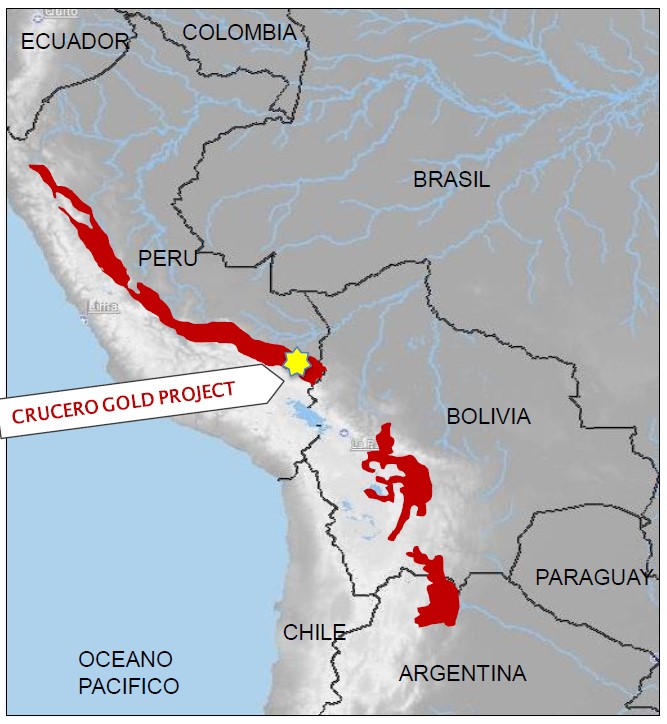
The Crucero Property ("Property") is located in Carabaya Province, in southeastern Peru, at approximately 14° 11’ south latitude and 69° 50’west longitude. The Property contains orogenic gold mineralization that is associated with pyrite and pyrrhotite as well as with minor arsenopyrite and stibnite and is contained within altered metasedimentary rocks belonging to the Ananea Formation of Lower Paleozoic age.
Exploration programs from 1996 to 2012 by previous operators included geological mapping, soil and rock geochemistry, trenching, surface geophysical surveys, diamond drilling (79 holes over 24,773 m) and metallurgical testwork. Drilling was concentrated on one of the geophysical anomalies referred to as the A1 Zone where a total of 72 core holes over 22,712 m were completed. The Property is comprised of three (3) mining and five (5) exploration concessions with an aggregate area of 4,600 ha and is held in the name of Blue Rock Mining S.A.C. ("Blue Rock"), a wholly-owned subsidiary of GoldMining Inc. (“GMI”). GMI owns a 100% interest in the Property through their ownership of Blue Rock.
Location
Carabaya Province, in southeastern Peru
Property Size
4,600 hectares
Ownership
100%
Commodity
Gold
Infrastructure
Road accessible, water, nearby electrical power (8 km)
Deposit Type
Orogenic gold
Location
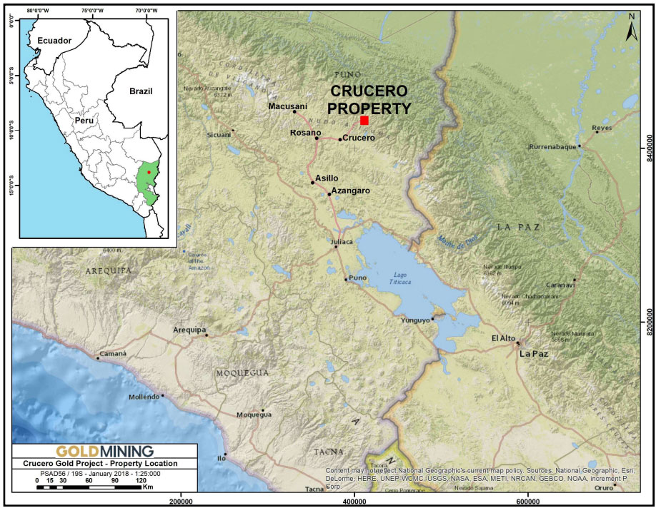
The Property is located in the eastern Cordillera of southeastern Peru in the Department of Puno, Province of Carabaya, District of Crucero, and the Quadrangle of Limbani (Figure 1). The Property is located at approximately 14° 10’ 49” latitude south and 69° 49’ 36” longitude west (Universal Transverse Mercator ("UTM"): 8433000S/410800E, Provisional South American Datum ("PSAD") 56 Zone 19 South) at an elevation of approximately 4,350 metres above sea level ("masl").
The village of Oscoroque (Caserio de Oscoroque) is located approximately 15 km to the south. The nearest major community is the city of Juliaca, about 150 km to the south-southwest, which has an airport that is served by domestic flights that connect with Arequipa, the second-largest city in Peru, about 180 km to the southwest. Lima, the capital of Peru, is located about 850 km northwest of Arequipa.
Figure 1: Crucero Property location map.
Geology and Mineralization
The Property is predominantly underlain by sedimentary rocks of the Ananea and Ambo Group. These rocks have been intruded by the Carabaya Batholith of presumed Permian or Triassic age (Figure 2). The sedimentary rocks strike northwest and have undergone folding and faulting as a result of compressional tectonics during the early Hercynian Orogeny. The Carabaya Batholith has a pronounced northwest-southeast elongation, presumably as a result of preferential emplacement rather than deformation.
Figure 2: Crucero Property regional geology map
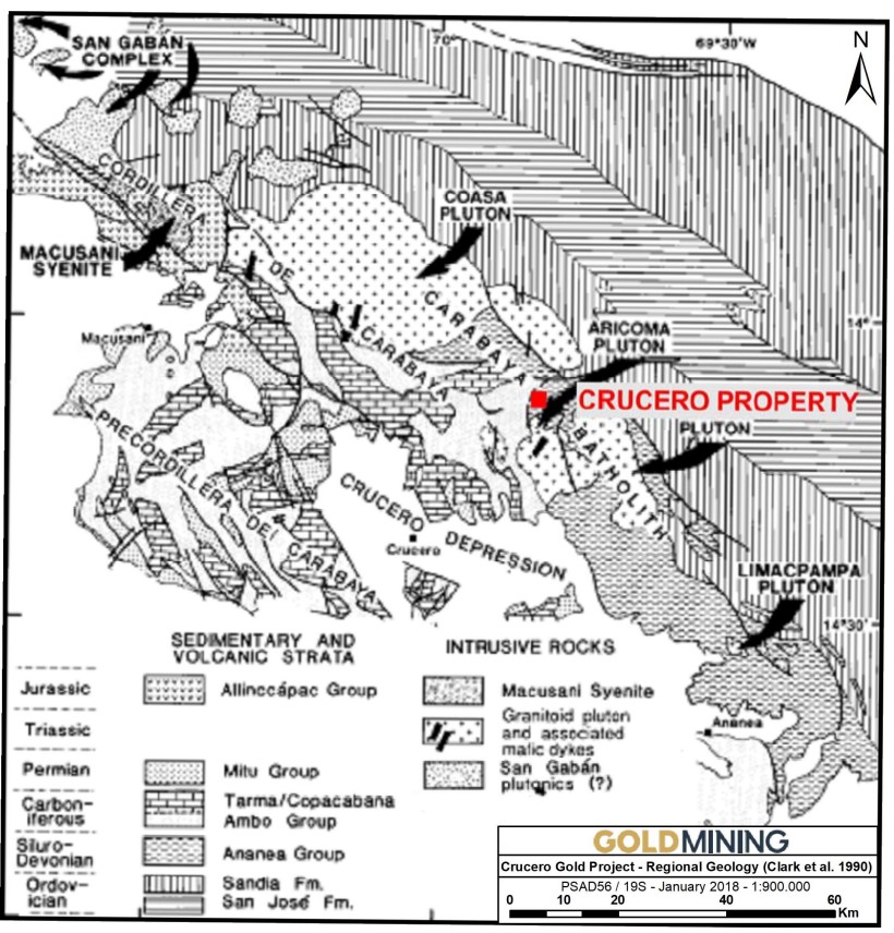
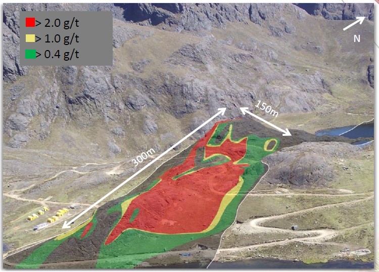
The A1 Zone area (which contains the mineral resources on the property), the most intensively explored portion of the Property to date, is underlain by Ananea Group clastic metasedimentary rocks that occupy the axial portion of a steeply-dipping, isoclinal fold that is inferred to be a syncline. The Ananea Group metasediments in this axial zone contain abundant pyrite and pyrrhotite and are variably altered and silicified (Figure 3). Immediately to the west of the area of trenching and drilling, the Ananea Group is in thrust contact (Ananea over Ambo) with quartzites of the Ambo Group. There are numerous structures parallel to this contact that are inferred to be thrust faults. Triassic-age monzogranitic plutons outcrop within about one kilometer of both the east and west boundaries of the Property. The northwest-trending fabric that dominates the Ananea Group metasedimentary rocks is offset by northeast trending normal faults that may postdate and offset the gold mineralization.
Figure 3: Crucero A1 zone geology.
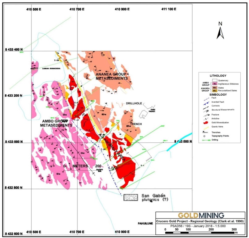
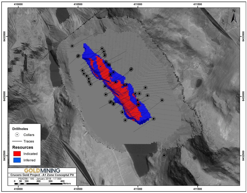
To date, exploration of the Property has concentrated on the A1 Zone (Figure 2). The A1 Zone dips vertically to steeply to the east and, as currently defined by trenching and drilling, is approximately 750 m long by 100 m in width and, in the central portion of the deposit, has been traced to a vertical depth of approximately 400 m although most of the mineralization appears to be confined to within about 200 m of surface.
The A1 Zone is hosted within meta-sediments (mudstones and siltstones) of the Ananea Group. Gold is the only mineral of economic interest and occurs together with pyrite, pyrrhotite, arsenopyrite and stibnite. Pyrite is the most abundant sulphide and typically occurs as blebs, the distribution of which commonly appears to be along foliation or bedding. Quartz veins are uncommon and are not necessarily gold-bearing, although the highest concentrations of gold found to date have been found in quartz veins. Quartz veins and veinlets cross-cut stratification.
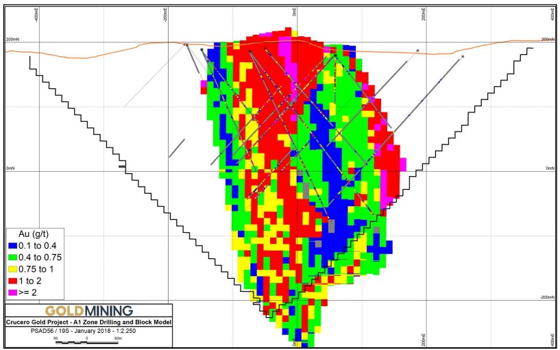
The style of mineralization, mineral association and degree of alteration varies with degree of deformation. From weak to strong deformation, the zoning observed is:
1. Weak deformation – in the outer margins of the A1 zone, pyrite and chlorite alteration is associated with varying amounts of gold mineralization;
2. Moderate deformation – is characterized by disseminated pyrite and pyrrhotite with better grade gold mineralization; and
3. Strong deformation – is characterized by disseminated pyrite, pyrrhotite, arsenopyrite, and stibnite with associated higher grades of gold mineralization. In the axial zone of the fold, sulphides and gold have been remobilized into axial-plane-parallel breccia zones.
Current Activities:
On November 21, 2017, GoldMining acquired the Property by acquiring Blue Rock, which holds ownership of the Property, from Lupaka, in exchange for shares and cash. GMI has done no exploration work on the Property since acquiring it in 2017. There are no mine workings or related development on the Property. There has been no production from the Property.
Exploration programs from 1996 to 2012 by previous operators included geological mapping, soil and rock geochemistry, trenching, surface geophysical surveys, diamond drilling (79 holes over 24,773 m) and metallurgical testwork. Drilling was concentrated on one of the geophysical anomalies referred to as the A1 Zone where a total of 72 core holes over 22,712 m were completed.
GoldMining is not planning any physical work on the Property in the immediate future, therefore no permits are required until such time as physical work is planned.
Resource Statement
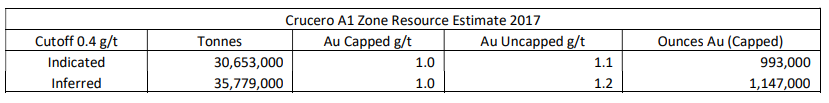
Notes to Resource Table:
1. Mineral Resources are not Mineral Reserves and do not have demonstrated economic viability.
2. There is no certainty that all or any part of the Mineral Resources estimated will be converted into Mineral Reserves.
3. Open pit resources stated as contained within a conceptual open pit above a 0.40 g/t Au cut-off.
4. Pit constraints are based on an assumed gold price of US$1,500/oz, mining cost of US$1.60/t and processing cost of US$16.00/t.
5. Mineral resource tonnage and contained metal have been rounded to reflect the accuracy of the estimate, and numbers may not add due to rounding.
6. Mineral resource tonnages and grades are reported as undiluted.
7. Contained Au ounces are in-situ and do not include recovery losses.
Based on technical report titled “Technical Report on the Crucero Property, Carabaya Province, Peru" with an effective date of December 20, 2017, which is available at www.sedarplus.ca under GoldMining’s SEDAR+ profile.
Gallery